The National Weather Service (NWS) defines a flash flood as a rapid rise in water level within 6 hours of the causative event. “Causative event” is usually heavy rainfall, but could also be due to a dam or levee failure, or from ice jam releases in colder climates. Flooding impacts that take longer than 6 hours to occur following the causative event is considered to be a “flood” instead of a “flash flood”.
In Hawaiʻi, flooding impacts can easily occur within 1 hour of the onset of heavy rainfall for small basins such as Waikāne Stream in windward Oʻahu, and Waiehu Stream in windward West Maui. Longer response times of 2 to 4+ hours occur in the larger basins (still very small by mainland U.S. standards), such as ʻŌpaeʻula Stream on Oʻahu, and Wailuku River on the Big Island. Flash floods in the larger basins can be especially dangerous for several reasons. One is that rainfall can be occurring well upslope, but the worst flooding impacts occur in the populated lower reaches that may not be raining at all. Similarly, intense rainfall can end upslope, and people can see improving skies or reduced reflectivity signatures on their radar apps, but not realize that a flood wave is on the way.
Even meteorologists, if they’re not careful and attentive, can be caught by surprise if they’re not wearing their “hydrologist” hat. One risk is that they may be focused too much on the meteorological aspects of the storm (e.g. intense rainfall radar echoes) and issue a flash flood warning with a warning polygon boundary that doesn’t include the downstream impact area. This would be a missed warning in terms of service. Another risk is canceling a warning prematurely based on diminishing rainfall in the headwaters upslope, but not considering the potential flood wave still on the way to impact areas in the lower reaches.
But getting back to the speed of flash floods…the March 23, 2026 flash flood event in the Ala Wai Watershed provides an illustration for how fast streams respond to intense rainfall. The watershed includes Mānoa Stream, Pālolo Stream, Makiki Stream, and Kanahā Stream, but the focus here will be on Mānoa Stream since it produced most of the damage from the flash flood event. It is relatively well-monitored with rain and stream gages in the headwaters region, a mid-point stream gage, and a stream gage in the lower reach near the outlet. The series of stream gages provides one of the few places in the state where you can watch the flood wave progression downstream.
The map below shows the Ala Wai Watershed boundary, Mānoa Stream and its main tributaries, and the rain and stream gages used in this case study. The rain gage here is the Lyon weather station, which is located at the Lyon Arboretum and is part of the Hawaiʻi Mesonet. Nearby is the Waihī Stream gage operated by the U.S. Geological Survey (USGS). Both are located in the headwaters region of Mānoa Stream. Waihī Stream captures flow from the western headwaters. The USGS also operates a gage on Waiakeakua Stream, which captures flow from the eastern headwaters and responds similarly to Waihī Stream. Runoff from rainfall at Lyon would be sampled by the Waihī Stream gage so I did not include Waiakeakua Stream data for simplicity.
Near the mid-point of the watershed is the USGS’ gage on Mānoa Stream at Woodlawn Drive (next to the Mānoa Marketplace). Overflow of Mānoa Stream at this location produced significant flooding impacts to vehicles and Noelani School. In the lower reaches, the USGS has a gage on the Mānoa-Pālolo Drainage Canal near Kaimukī High School. The distance from the Waihī Stream gage to the Mānoa-Pālolo Drainage Canal gage is around 3.5 miles.

Map showing the Ala Wai Watershed boundary (red) and Mānoa Stream (blue). The cyan colored dots are the locations of the Lyon rain gage and the 3 USGS stream gages used in this post. The watershed boundary and stream lines are from the Statewide GIS Program. Locations for the gages are from the Hawaiʻi Climate Data Portal (HCDP) and the USGS.
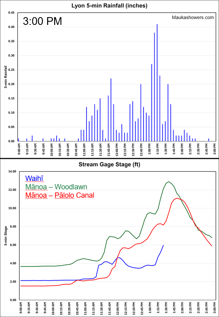
The loop below shows rainfall and stream levels from 9:15 AM to 3:00 PM HST on March 23, 2026. The top panel plots 5-minute rainfall from the Lyon weather station in 15-minute time steps, so you’ll see rainfall data show up in batches of 3 at a time. The bottom panel shows stage levels at Waihī Stream (blue), Mānoa Stream at Woodlawn Dr. (green), and the Mānoa-Pālolo Canal (red). The stream gage data are also 5-minute data points plotted in 15-minute time steps.
The rain gage data from Lyon shows occasional light rain in the mid-morning. Rainfall intensifies around 10:45 AM and fluctuates until around 1:00 PM when a thunderstorm over the headwaters produces a spike in intensity. A peak rainfall rate of 4.92 inches per hour (0.41 inches in 5 minutes) occurs at 1:20 PM. Waihī Stream reacts very quickly to the headwaters rainfall and lags Lyon by only 5 to 10 minutes. The Waihī Stream stage peaks at 1:30 PM when the gage goes offline. I don’t know if this was due to the flood waters taking out the sensor or some other technical issue. Waiakeakua Stream to the east (not shown) peaked at 1:25 PM so I don’t think the Waihī Stream peak extends much higher. Farther down the valley, Mānoa Stream at Woodlawn Drive peaks at 1:40 PM, just 10 minutes after the Waihī Stream peak, and 20 minutes after the rainfall burst was picked up at the Lyon gage. The flood wave reaches the Mānoa-Pālolo Canal gage at 1:55 PM, just 15 minutes after overflowing at Woodlawn Drive.

Loop of 5-minute rainfall data (top panel) from the Lyon weather station and 5-minute stream stage data (bottom panel) from the USGS gage at Waihī Stream (blue), Mānoa Stream at Woodlawn Drive (green), and the Mānoa-Pālolo Canal (red). The data are for the period from 9:15 AM to 3:00 PM HST on March 23, 2026 and are plotted in 15-minute time steps (batches of three 5-minute data points at a time). Lyon data are from the Hawaiʻi Climate Data Portal (HCDP), and the stream gage data are from the USGS.

Same as above except just the frame for 3:00 PM HST to show the full plot.
The following table summarizes the peak rainfall and flow times at the different sites. The flood wave took about 25 minutes to travel about 3.5 miles from the Waihī Stream gage to the Mānoa-Pālolo Canal gage. This comes out to an average speed of 8.4 miles per hour. Various sources online state that a flash flood moves at around 6 to 12 miles per hour, so the Mānoa Stream flood wave falls right within that range.
| Peak event | Time (HST) |
| Rain intensity at Lyon | 1:20 PM |
| Flow at Waihī Stream | 1:30 PM |
| Flow at Mānoa Stream at Woodlawn Dr | 1:40 PM |
| Flow at Mānoa-Pālolo Canal | 1:55 PM |
NWS forecasters have very little time to make a decision to issue a Flash Flood Warning with much lead time. Once rainfall is detected, a forecaster must decide if it will persist long enough over the basin to cause a problem. Most basins are not instrumented as well as the Mānoa Stream basin, and forecasters often have to depend solely on radar data, which only provides an estimate of rainfall that may not be accurate, and no stream gage data to verify a streamflow response.
The rapid onset of the flood wave also shows there is very little time to react to heavy rainfall upstream. Therefore, the best time to prepare for a flash flood is during the Flood Watch phase, or even before that for longer lead time issues. By the time heavy rain starts, you only have time to react to the threat.