Note: This blog post will NOT be updated with the latest forecast information regarding the upcoming potential heavy rain event. For the latest community updates, please stay tuned to your local media outlets, and check on the latest official forecasts, watches, and warnings on the Honolulu Forecast Office’s (HFO) website.
Happy New Year, everyone! I hope you had a great holiday season and have a healthy and prosperous 2026! I just got back from visiting the family in Hilo. In addition to eating lots of food, I’ve been keeping an eyeball on a developing weather event that could start affecting the main Hawaiian Islands starting Sunday, January 4 (yes, tomorrow!). The National Weather Service’s (NWS) Honolulu Forecast Office (HFO) already issued a Flood Watch yesterday for the entire state. I’m doing a short post today to show what we may get in terms of rainfall from the upcoming storm system.
The GOES-18 infrared (IR) image loop from this morning (below) shows the developing low pressure system aloft to the north of the state. Models are projecting that this low will move southwest to a position west of Kauaʻi on Monday, then will shift southeastward to a position southwest of the island chain on Tuesday. The second loop below is a simulated IR loop from the ECMWF model that shows one possibility of how this event may evolve through 2 AM HST Thursday, January 8.

NOAA/NESDIS GOES-18 infrared image loop from 8:10 AM to 10:00 AM HST Saturday, January 3, 2026. The yellow circle indicates the position of a developing low pressure system aloft that will destabilize the atmosphere over the Hawaiian Islands. The main Hawaiian Islands are below the yellow circle.

Simulated color enhanced IR satellite image loop from the ECMWF model 11 PM HST Saturday, January 3 to 2 AM HST Thursday, January 8, 2026. In this enhancement scale, gray shades are either the surface or low cloud tops. Blue, green, yellow, and orange shades are high cloud tops Graphics provided by WeatherBELL Analytics.
As the low aloft gets closer to the islands on Saturday night and Sunday, heavy showers and thunderstorms could develop over portions of the state. The change in conditions could occur rather quickly. The pair of images below shows what the high resolution ARW model thinks the radar picture could look like over the next 24 hours or so. The upper image is the simulated reflectivity valid at 6 PM HST Saturday, January 3. The lower image is valid just 12 hours later at 6 AM HST Sunday, January 4. The oranges and reds show intense precipitation cores as forecasted by the model. Note how the model is projecting a significant increase in intense precipitation as the low aloft draws closer to the state. Other high resolution models show variations of the same theme but differ on the placement of the cores.


Simulated composite reflectivity from the high resolution WRF-ARW model. The top panel is valid for 6 PM HST Saturday, January 3. The bottom panel is valid at 6 AM HST Sunday, January 4, 2026. Graphics are from the ARW-Hawaiʻi section of the NWS Model Analyses and Guidance webpage.
The part of the event that concerns me is when the low aloft shifts southwest of the state. As mentioned above, this is expected to occur on Tuesday if the models are correct. If this occurs, the system will be pulling significant moisture over the state in conjunction with unstable conditions aloft. These ingredients make things very favorable for heavy rainfall production, especially along the southeastern half of the Big Island.
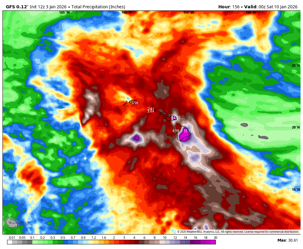
Unlike the mid-December event which mainly affected Kauaʻi and Oʻahu, this event is expected to affect the entire state to some degree, and this is reflected in HFO’s Flood Watch. Although the specific amounts vary from place to place, the statewide event coverage is consistent among the various models. Two examples are shown below. These are from ECMWF (top) and the GFS (bottom), and depict the total precipitation forecasted by the model from 2 AM HST Saturday, January 3 (model start time) through 2 PM HST Friday, January 9.

Total ECMWF precipitation from 2 AM HST Saturday, January 3 (model start time) through 2 PM HST Friday, January 9. Graphics provided by WeatherBELL Analytics.

Same as above but for the GFS model.
Note the significant amounts projected for the Big Island (>15 inches) and Maui. Even though the Big Island can handle a lot of rain, events of this magnitude historically have produced widespread impacts, especially to flood-prone roads. These include, but are not limited to:
- Highway 11 (Māmalahoa Highway) at Kāwā Flats south of Pāhala.
- Multiple locations along Wood Valley Road.
- Cane Haul Road and Kaʻalāiki Road southwest of Pāhala and mauka from Highway 11.
- Pōhaku Drive in Puna at Waipāhoehoe Stream (normally a dry wash).
- Bayfront portion of Kamehameha Ave in Hilo.
- East Kawailani St. in Hilo.
- Kukila St. in Hilo (near Prince Kūhiō Mall)
- Railroad Ave. in Hilo (industrial area portion)
For Maui, heavy rainfall along the east and southeast flanks of Haleakalā can cause road closures in numerous locations. These include, but are not limited to:
- Hāna Highway, especially east of Keʻanae.
- ʻUlaʻino Road (makai from the Hāna Highway and west of the Hāna Airport).
- Piʻilani Highway at Kālepa Gulch.
- Piʻilani Highway at Pahihi Gulch.
- Piʻilani Highway at Hawelewele Gulch.
If you plan to travel over any of these locations, you may want to have alternate plans in case these roads are closed due to flooding. Of course, many other roads and properties can become flooded as well, and streams may overflow their banks, especially if rainfall intensities are high and/or the event duration is long. Pay attention to impact reports from HFO as the event evolves for more details.
I want to get this posted sooner than later, so I’ll end by copying and pasting the preparedness tips and additional resources I included in my post prior to the mid-December event.
- Do not drive on roads with fast-flowing water.
- Just 1 to 2 feet of fast-flowing water can sweep most vehicles off a road.
- Do not walk across flooded streams.
- If you’re hiking and get stranded, wait for the water to recede.
- Expect other rainy weather impacts.
- Increased road travel times.
- Possible detours or road closures due to flooding or landslides.
- Outdoor activities may be postponed, canceled, or adjusted.
- The wet season brings increased potential for lightning strikes.
- Be prepared for power outages, especially when thunderstorms are forecast.
- Move indoors when you hear thunder or see a flash of lightning.
- Lightning strikes can occur even in areas where it is not raining.
- Although rare, thunderstorms occasionally produce damaging winds, large hail, and tornadoes in Hawaiʻi.
- If you live in a flood-prone area, have an evacuation plan in case flood waters quickly threaten your home.
Additional resources:
- Hawaiʻi Emergency Management Agency (HIEMA): As mentioned in my Hurricane Kiko post, HIEMA’s website contains a wealth of preparedness information for many natural hazards.
- County Emergency Management Agencies: Your respective county emergency management offices will have specific information affecting your county, including availability and status of evacuation shelters.
Be prepared and stay safe!