On March 12, while we were paying attention to the initial impacts of the first kona low, the National Oceanic and Atmospheric Administration’s (NOAA) Climate Prediction Center (CPC) issued an El Niño Watch. By now, many people have at least heard of the term “El Niño”, even if they may not understand what it really is. A short version of an El Niño description is an anomalous warming of the ocean surface in portions of the equatorial Pacific. This warming can produce significant shifts in weather patterns that can last for several months. El Niño is also the warm phase of the El Niño/Southern Oscillation (ENSO) cycle. La Niña is the cool phase of ENSO, and we’re currently in the waning days of a weak episode that started last fall.
So what does an “El Niño Watch” mean? That’s a good question, thanks for asking! CPC issues an El Niño Watch “when conditions are favorable for the development of El Niño conditions within the next six months”. Looking at their ENSO probabilities (graph below), the climate state should switch to ENSO-neutral (gray bars, in between El Niño and La Niña states) soon, then transition to El Niño (red bars) some time this summer. Since CPC updates their ENSO status only once per month (usually the second Thursday), La Niña may have already ended. We will have to wait until next Thursday to see CPC’s update.

NOAA CPC’s 3-month probabilities for El Niño (red), La Niña (blue), and ENSO-neutral (gray). The x-axis shows 3-month seasons from February-March-April (FMA) 2026 through October-November-December (OND) 2026.
The possibility of an El Niño developing this summer is not a huge surprise. CPC’s ENSO probabilities from January already showed the possibility of El Niño development in mid-2026, though confidence was lower at that time.

Same as above, but for the January 2026 forecast.
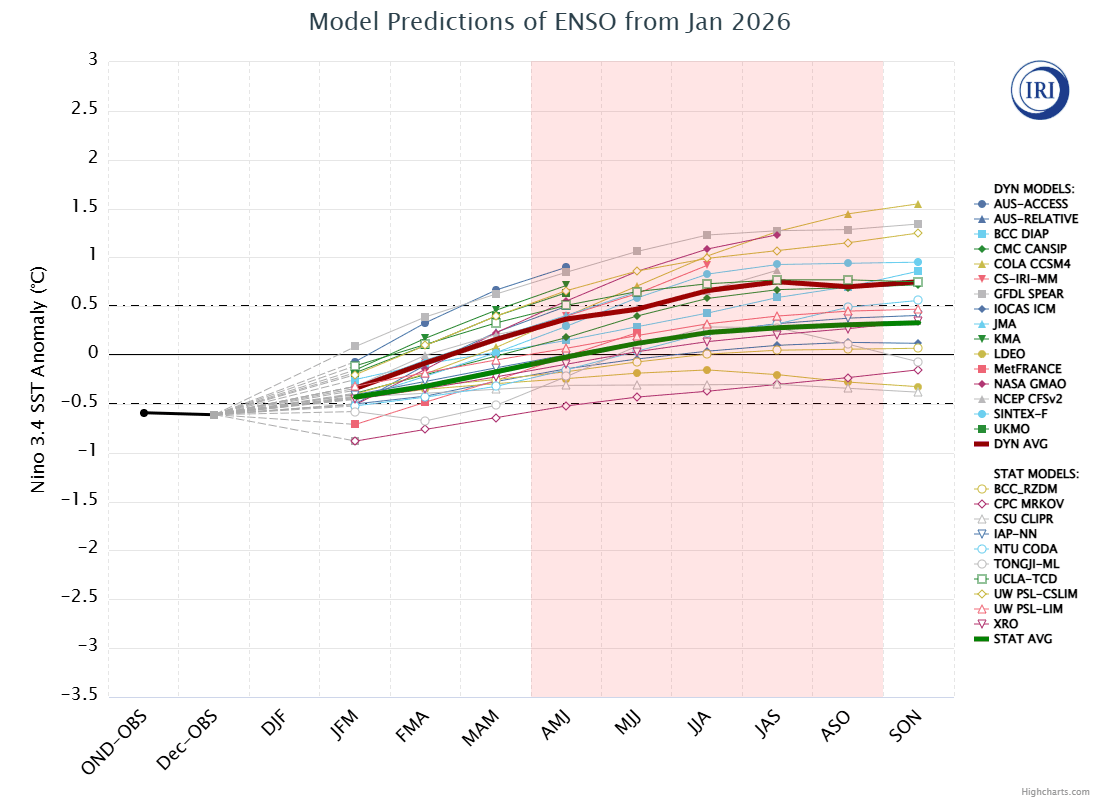
Looking at it another way, the loop below shows forecasts from dynamical and statistical models of sea surface temperature (SST) anomalies for the “Niño 3.4” region of the equatorial Pacific. A map showing the Niño 3.4 region is included below the loop for reference. Many climate experts focus on this region to help determine the ENSO phase. When the 3-month SST anomaly in Niño 3.4 is at or above +0.5 degrees C, it’s an indicator that El Niño is occurring. If the anomaly is at or below -0.5 degrees C, then it’s an indicator of La Niña. Anomalies between the two thresholds are considered to be ENSO-neutral territory. As the frames in the loop go from January to March, note how both the dynamical and statistical models trend toward warmer anomalies, or deeper into El Niño territory. The spread in the March plume diagram shows that there’s considerable uncertainty in the expected intensity of the El Niño episode so we’ll just have to be patient and see how the forecasts evolve over the next few months.

Loop of forecast graphs from the Columbia Climate School’s International Research Institute (IRI) showing the January through March 2026 model forecasts for SST anomalies in the Niño 3.4 region. Each line is a different climate model. Lines with filled icons are the dynamical models, and those with unfilled icons are statistical models. The dynamical consensus is the bold, dark red line, and the statistical consensus is the bold, dark green line. The x-axis shows 3-month seasons, with “DJF” indicating December-January-February, “JFM” indicating January-February-March, and so forth. I added the light red shaded region to show the period of Hawaiʻi’s May through September dry season.

Map showing the location of the Niño 3.4 region used to monitor ENSO conditions.
These climate graphs are nice and all, but what does a possible El Niño mean for Hawaiʻi’s weather during the upcoming summer? Many of you are familiar with the tendency for the Central North Pacific (CNP) tropical cyclone basin (north of the equator, between 140W longitude and the International Dateline) to have more tropical cyclones when El Niño is present. So there’s that. Keep in mind that this is activity in the entire CNP basin, and not necessarily direct impacts to Hawaiʻi. The graph below shows the number of tropical cyclones in the CNP by year. There’s considerable year-to-year variability, and the most active years tend to occur when El Niño is present during the peak activity months of July, August, and September. You may be wondering what “RONI ver” in the legend means. “RONI” stands for Relative Oceanic Niño Index and is used to better account for changes to the baseline climate state. CPC replaced the old ONI with RONI recently, and it resulted in a reclassification of some of the ENSO events. I included a version of the graph using the old ONI below so you can see the changes to the event classifications in some years.

Graph of the annual number of tropical cyclones in the CNP from 1970 through 2025. Red bars indicate El Niño during July-August-September (JAS), blue bars indicate La Niña, and yellow bars indicate ENSO neutral. Data provided by the Central Pacific Hurricane Center. Bar colors based on Relative ONI (RONI) data from CPC.

Same as above, but with bar colors based on the legacy ONI data.
What about rainfall? According to the ENSO precipitation climatology atlas (Sutton et al. 2023), the area around the main Hawaiian Islands has above average summer precipitation during El Niño episodes, regardless of episode intensity. The figures below are from the climatology atlas and show the departures from average during the June-July-August (JJA) season for both weak and moderate-to-strong El Niño events. The Hawaiian Islands are in the upper right portion of the figures. The analysis doesn’t address variability though, and it can be considerable.

Map of precipitation changes from the average across the tropical central and west Pacific during weak El Niño events. The map covers June through August preceding El Niño onset and was pulled from Sutton et al. (2023).

Same as above, but for moderate to strong El Niño events.
To illustrate the variability, I looked at Standardized Precipitation Index (SPI) data from the Hawaiʻi Climate Data Portal (HCDP) for the past 3 times that the RONI was in El Niño territory during the summer. This would be 2004, 2015, and 2023. The 2004 El Niño was a weak event, 2015 was very strong, and 2023 was moderate to strong. The maps below show SPI values over the main Hawaiian Islands for the June-July-August period for each El Niño event.
The map for 2004 shows near to above normal rainfall over most areas of the state, with the windward Big Island being the main exception at mostly below normal. Yes, the east tip of Maui shows “extremely dry”, but I’m suspicious of that spot because it may be due to bad data from one rain gage (Hāna Airport?) in the area. I haven’t had the chance to check for sure, but I’m always suspicious of “bullseyes” like that which are very different from other locations in a similar climate region. In the summer of 2015, during an intensifying event that would reach “Super El Niño” status, it was wetter than normal in most areas of the state, especially in the leeward areas. This was also the year with a record-shattering number of tropical cyclones in the CNP basin. The June-August SPI for 2023, during a moderate to strong event, rainfall across the state was near to below normal in most areas, and I’m suspicious of the data for the areas showing very wet conditions. In short, summer rainfall during El Niño is kind of all over the place, and not consistently above average.

SPI analysis from the Hawaiʻi Climate Data Portal (HCDP) covering the June through August 2004 period.

Same as above, but for 2015.

Same as above, but for 2023.
So what level of rainfall can we expect this summer? At this point, who knows? Yes, the climate models do have projections that extend into the summer months and beyond, but I would prefer to wait for things to shake out a bit before really taking a look.
References
Sutton, J., N. Luchetti, E. Wright, M.C. Kruk, and J.J. Marra, 2023. An El Niño Southern Oscillation (ENSO) based precipitation climatology for the United States Affiliated Pacific Islands (USAPI) using the PERSIANN climate data record (CDR). NOAA.