The May through September 2025 dry season has ended, and I couldn’t be happier. There were times in August and September where it felt like the stupid dry season was just dragging on and on, with loads of heat and humidity, and little to no rain. While it’s still relatively warm and definitely humid, the rainfall has picked up recently, and we even had south winds over Kauaʻi and Oʻahu yesterday (Oct 9).
Last week I provided an overview of the hydrology products that the Honolulu Forecast Office (HFO) issues during heavy rain events. Rather than continue on that theme, I thought that this week I’ll provide a wrap-up on the 2025 dry season and take a look at what may be in store for us in the months ahead. I’ll continue on the hydrology products theme again next week.
Back in May, HFO released their dry season outlook, which is based on guidance from the National Oceanic and Atmospheric Administration’s (NOAA) Climate Prediction Center (CPC). The outlook indicated that probabilities favored above normal precipitation for Kauaʻi and Oʻahu, and below normal precipitation for the Big Island. So what do the final dry season numbers tell us? The map below shows the 2025 dry season rainfall expressed as a percent of the long term average. The shading shows that most of the Big Island and Maui County had below average rainfall, Oʻahu was mostly near to below average, and most of Kauaʻi was near to above average. Sounds like the forecast was pretty good, overall!

Percent of average rainfall for the May through September 2025 dry season over the main Hawaiian Islands. Rainfall data are from NOAA and the Hawaiʻi Climate Data Portal (HCDP). Average rainfall values are also from the HCDP.
While there was a fairly robust flash flood in the Hanalei River basin in late July, the rest of the dry season was notable for its brutal dryness in many parts of the state. In other words, drier than the usual dry. Hilo Airport and Waiʻaleʻale stood out for having their lowest August rainfall totals in long periods of continuous record going back to 1950 and 1968, respectively. According to HFO’s Monthly Precipitation Summary, there were over three dozen sites across the state that had record low August rainfall.
HFO’s Drought Information Statements indicated that salient impacts from the lack of rain included an increase in brush fire incidents, extremely poor forage conditions for producers, and an increase in public water supply impacts. The U.S. Geological Survey (USGS) streamflow map for August (below) showed most of their sites in the “Much below normal” or “Low” categories. September showed slight improvement, but most sites were still at “Much below normal” or “Low” levels. I don’t remember the monthly streamflow maps looking this bad. While memory, especially mine, is not the best measure of things, I think it’s safe to say that streamflow conditions are pretty bleak when you have that many sites below the 10th percentile.

Map of August 2025 streamflow levels at USGS sites across the state. Percentile classes are listed at the bottom.

Same as above but for September 2025.
Based on these impacts, the U.S. Drought Monitor (USDM) map as of October 9, 2025 showed severe drought (D2 category on the map) over large portions of Maui County and the Big Island. The worst portions of the Big Island were classified as being in extreme drought (D3 category).

U.S. Drought Monitor map for the main Hawaiian Islands. The D1-D4 categories are the different levels of drought. The D0 category, for abnormally dry conditions, can be considered as “pre-drought”. The latest and archived USDM maps can be found here.
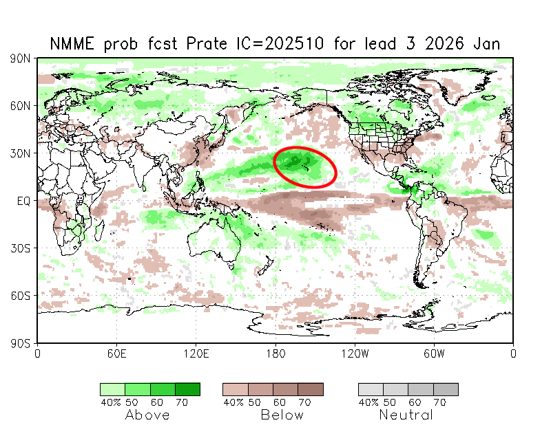
Well, that should be enough for the depressing news. Now that we’re finally in the wet season, what can we look forward to in the coming months? The updated North American Multi-Model Ensemble forecasts (NMME, Kirtman el al. 2014) were released a couple of days ago and I put the monthly frames into the loop below. The maps show the probability of precipitation across the globe and spans the period from November 2025 through May 2026, so it covers the rest of the October 2025 through April 2026 wet season and the start of the 2026 dry season. After a transition month in November, it looks like above normal precipitation is favored from December 2025 through the rest of the wet season and even into the start of the 2026 dry season. This outlook has been quite consistent over the past couple of months so it shows that the models have not been wavering much. HFO should be coming out with their official wet season outlook later this month so we’ll see what they’re expecting.

Loop of monthly precipitation probability forecasts from the October 2025 run of the NMME. The loop covers the period from November 2025 through May 2026. Brown shades are areas where probabilities favor below normal precipitation. Green areas favor above normal precipitation. The red oval indicates the location of the Hawaiian Islands.
Why are the models pointing toward a wetter than normal wet season? The main reason is likely due to La Niña. In case you missed it, NOAA’s Climate Prediction Center (CPC) issued a La Niña Advisory yesterday, which means that La Niña conditions are present in the Pacific. CPC’s latest El Niño Southern Oscillation (ENSO) probabilities in the figure below show that they are expecting La Niña conditions to persist only through the December 2025 through February 2026 period, followed by a transition to ENSO-neutral conditions from January through March 2026. CPC is also leaning toward a weak La Niña event, which favors above normal rainfall over the main Hawaiian Islands. Moderate to strong La Niña events tend to be drier because the enhanced rainfall tends to be shifted to the west. I covered these items in more detail in my August 22, 2025 post so check it out.

NOAA CPC’s 3-month ENSO probabilities for El Niño (red), La Niña (blue), and ENSO-neutral (gray). The x-axis shows 3-month seasons, with SON indicating September, October, November, and so forth.
We’ll see how this all plays out over the next several months. With these probabilities in the NMME, I would normally be quite bullish about wetter than normal conditions during the wet season. However, the reminder from last season is to temper expectations and be more cautious about how much wetter it will be this time.
Reference
Kirtman, B.P., D. Min, J. Infanti, et al., 2014: The North American multimodel ensemble: Phase-1 seasonal-to-interannual prediction; Phase-2 toward developing intraseasonal prediction. Bull. Amer. Meteor. Soc., 95, 585-601.