
Ahhhh, the wet season is finally here. I look forward to having several months of cooler weather, more dynamic weather patterns, and with it, the potential for more rainfall to rejuvenate my plants and soil. Having more dynamic weather also increases the likelihood of hazardous weather conditions. In response, the National Weather Service’s (NWS) Honolulu Forecast Office (HFO) will issue many more products during the wet season to inform their key partners and the public of what they can expect from each event. The range of phenomena that can affect the Hawaiian Islands is quite large, ranging from flash floods to severe thunderstorms, and even winter weather conditions on the upper elevations of Mauna Kea, Mauna Loa, and Haleakalā. Each phenomenon presents different threats and requires different actions to stay safe so the NWS has literally dozens of products to handle the varying conditions. I’ve listed many of them in the figure below. If you think that’s a lot, I didn’t even include them all! There are so many that it can be confusing, even for Mele (my dog), and she’s really smart! I should also note that the list of products was pared down relatively recently, part of the NWS’ Hazard Simplification effort. So if you think this is a lot, it was worse just a few years back.

Word cloud of many (but not all) of the products issued by the NWS during significant weather and marine events. A full list can be found on the NWS’ Hazards Map help page.
Since my focus in this post is on HFO’s hydrology products, I’ve pared the list down to just five that are applicable during flash flood events. These products cover different event lead times and convey varying levels of urgency and event severity. I will be providing just an overview of the products in this post. In later posts, I’ll go into more details about each of them and cover what they mean, and when and why each is issued.
I mentioned in last week’s post that all flood events in the Hawaiian Islands are considered to be flash floods because they occur within six hours of the causative event. The cause, in this case, is often heavy rainfall. Anticipating the specific location, timing, and intensity of heavy rainfall cannot yet be done reliably with significant lead time. However, the atmospheric conditions that support the production of heavy rainfall can be anticipated several days in advance. In other words, forecasters can’t reliably tell you that rain rates of 2 to 3 inches per hour will occur over Mānoa Valley in 2 days or even 6 hours from now, but they often have enough confidence to tell you that heavy rain is possible over Oʻahu in the next 1 to 2 days. This confidence varies depending on the situation. Sometimes confidence is high enough to push mentioning heavy rain potential beyond a couple of days. In other times, the heavy rain event may go unforecasted.
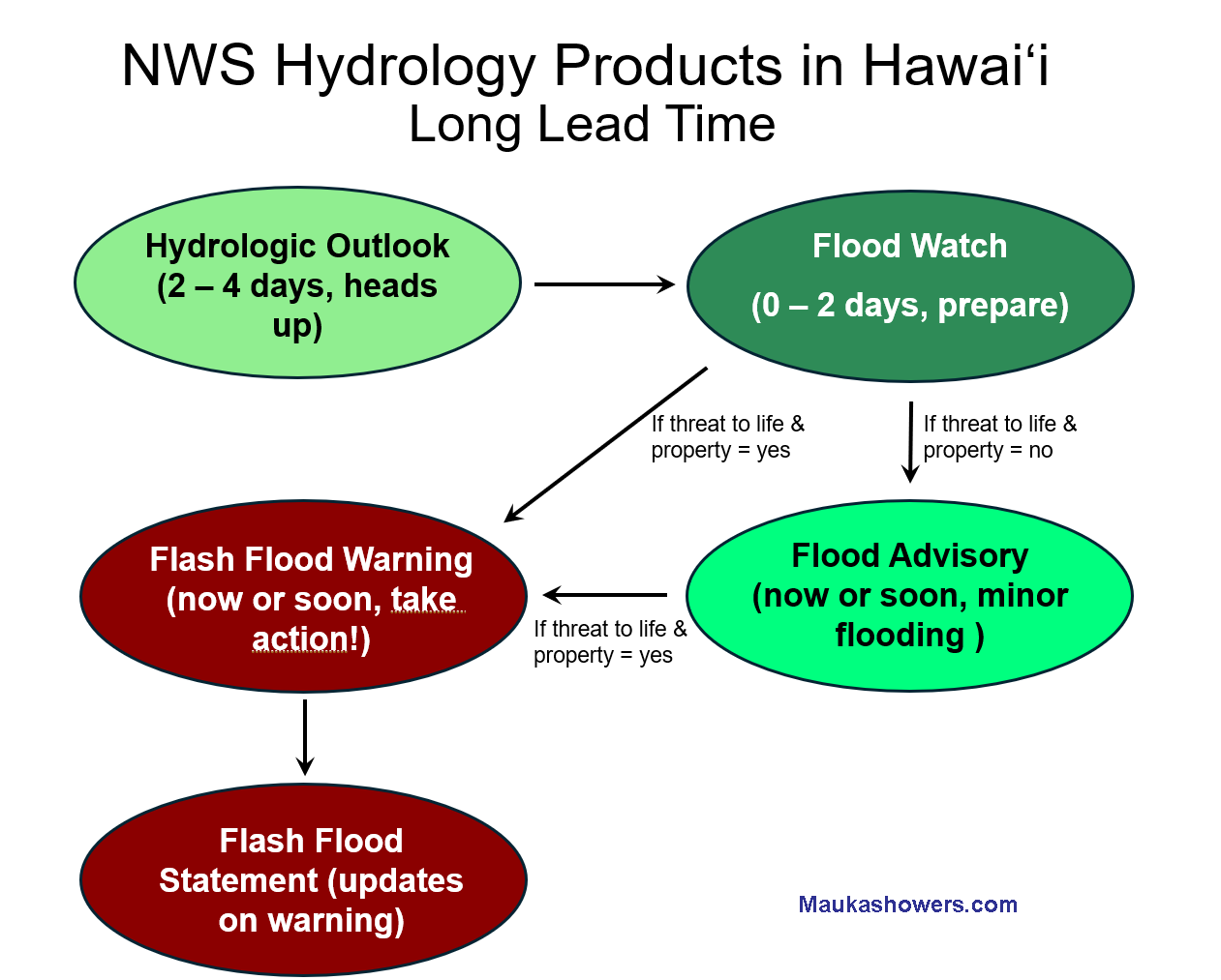
In an ideal situation, let’s say that most of the weather model forecasts and tools indicate that a large-scale heavy rain event is possible over the Hawaiian Islands some time in the next 2 to 4 days. This could be in the form of an approaching tropical cyclone or a large, slow-moving kona low. During this type of scenario, the full range of HFO’s hydrology products can be rolled out as the event evolves. The flow chart below shows the sequence of product issuance, depending on how far out in time the expected heavy rain event occurs, and the level of severity.

Flow chart of NWS HFO products that can be issued during a long lead time flash flood scenario. The chart is an adaptation of a version I created for NWS outreach and training activities. The colors used here are identical to those used on the weather.gov hazards map.
If there is enough confidence that widespread heavy rainfall and flash flooding will occur somewhere in the main Hawaiian Islands in the 2- to 4-day time frame, HFO will issue a Hydrologic Outlook. The intent of this product is to provide a heads up notification that a significant hydrologic event is coming up. At this point, forecasters can’t tell you which specific islands will be impacted, or the exact timing, so stay tuned. As the anticipated heavy rain gets within the 2-day time frame, forecasters will issue a Flood Watch, which supersedes the previously issued Hydrologic Outlook. The issuance of a Flood Watch means forecasters believe flash flooding is possible within the next two days, and they may be able to narrow down which islands will be affected. The intended reaction to a Flood Watch is preparation. Emergency managers and first responders can take a “lean forward” posture in anticipation of heavy rainfall and its resultant flash flooding.
When the storm event arrives, it often starts out with some areas of rainfall that could have pockets of moderate or even heavy intensities. Some of the rainfall could produce minor or nuisance flooding, such as ponding on roads that can impede traffic. This is especially true in highly urbanized areas such as Oʻahu where traffic slows down when it’s cloudy. I’m joking…but only slightly. Streams can have elevated water levels, but none are expected to overflow at that point. In these situations, HFO will issue a Flood Advisory to inform people that heavy rainfall is producing nuisance flooding. Forecasters will also be more specific with this product and indicate which areas are affected by the heavy rain and its downstream effects.
If the heavy rain persists or intensifies, and the resultant flooding becomes a threat to life and property, forecasters will then upgrade the Flood Advisory to a Flash Flood Warning. When a warning is issued, it is too late for preparations. Just immediately do what it takes to stay out of harm’s way. This means get out of streams and low-lying or flood-prone areas. By definition, a Flash Flood Warning means that flooding is imminent or already occurring, but forecasters try to provide as much lead time as possible. Unfortunately, the nature of flash floods in Hawaiʻi means that the amount of lead time, if any, is usually less than an hour. Once a Flash Flood Warning is issued, forecasters will provide updated information on the warning with a Flash Flood Statement. This information can include flooding impacts, updates on the location(s) of intense rainfall, and observed rainfall amounts.
An unfortunate reality is that not all heavy rain and flash flood events can be anticipated well in advance. There are times when rainfall ends up being much more intense than forecasted, or flooding impacts end up being worse than expected for the observed amount of rainfall. In these situations, no Hydrologic Outlook or Flood Watch can be issued to provide a long lead time notification, so it’s just reaction products that are issued based on observational data or reported impacts. The flow chart below shows the product sequence during these short notice or no notice events, and is essentially the same as above, but without the outlook or the watch as an option.

Same as above, except for short notice or no notice events where longer lead time products cannot be issued.
I think that’s enough for an overview of the hydrology products. A mainland U.S. office would also have Flood Warning products to cover flooding in the main stem rivers that usually rise at slower rates. But that’s outside the scope of my blog.
In next week’s blog post, I plan on looking back at the 2025 dry season and summarizing the numbers. I should have access to the latest North American Multi-Model Ensemble forecasts so I can show that as well. After that, I’ll resume talking about HFO’s hydro products again and go into more details about each of them.