I thought I would write about something different this week. Like everyone else (big assumption here), I’ve always wanted to do a comparison between the clouds I see from an airline window and what they look like in satellite images. To me it’s interesting because what you see out of an airplane window is like walking past a mural. You can see a particular cloud feature for only a few minutes, and because your motion in the plane is much faster than the motion of the cloud, you can’t discern any significant changes or movement by the cloud before it disappears from your field of view. And since you’re viewing clouds at an angle, you can see more of its 3-D structure. Meanwhile, a satellite image provides you only with a top down view at much lower resolution than what you can see from an airplane. A loop of several images 10 minutes apart typically spans several hours and reveals the dynamic evolution of the cloud field that looks very different from the “still image” you see out the window.
An opportunity to more closely examine the two perspectives came up on January 31, when I flew from Hilo to Honolulu. I’ve tried to do this before on a couple of occasions over the years, but prior to airline tracking apps, I didn’t know for sure where the aircraft was located when I took the pictures. Then when the tracking apps became available, the problem became remembering to download the satellite images that correspond to the times of the pictures taken from the plane. This time I have all the pieces of the puzzle.
Weather conditions on January 31 were nothing special. The large scale surface winds were weak from the east to southeast, which allowed decent afternoon upslope flow and clouds to develop over the Big Island and Haleakalā on Maui. The GOES visible satellite image loop below shows conditions that afternoon.

GOES visible image loop produced by Tropicaltidbits.com. The loop covers the period from 2:35 PM to 4:55 PM HST, January 31, 2026.
I started taking pictures at 3:14 PM HST from the right side of the aircraft several minutes after taking off from Hilo. At this point, the aircraft was flying northwestward over the windward Hāmākua coast of the Big Island, marked by the X in the satellite image below. There’s a “sideways Y” feature in the cloud field to the north of the Big Island. The intersection of the arms of the “Y” is identified as feature “A” in the satellite image. This cumulus cloud is taller than the others in the nearby cloud field and is the most prominent within that portion of the cloud lines in the satellite image. My guess is that this particular cloud may be benefiting from slightly stronger low level air convergence at the intersection of the two lines, which could provide slightly stronger upward “oomph” or “yoisho” for greater height. The lower arm of the “Y” is feature “B” and is barely resolvable in the satellite image. Note that in the aerial image, there’s more space between the individual clouds. The gaps between the clouds is allowing the sea surface to be averaged with the clouds in the 500-meter x 500-meter resolution of the satellite sensor in the visible wavelengths, producing only light gray specks in the image.

GOES visible image produced by Tropicaltidbits.com. The image is for 3:15 PM HST, January 31, 2026. The “X” marks the approximate position of the aircraft. Features “A” and “B” are referenced in the aerial image from 3:14 PM HST below.

Picture I took out the right side window of the aircraft at 3:14 PM HST, January 31, 2026. Features “A” and “B” in the picture are the same features identified in the 3:15 PM HST satellite image above.
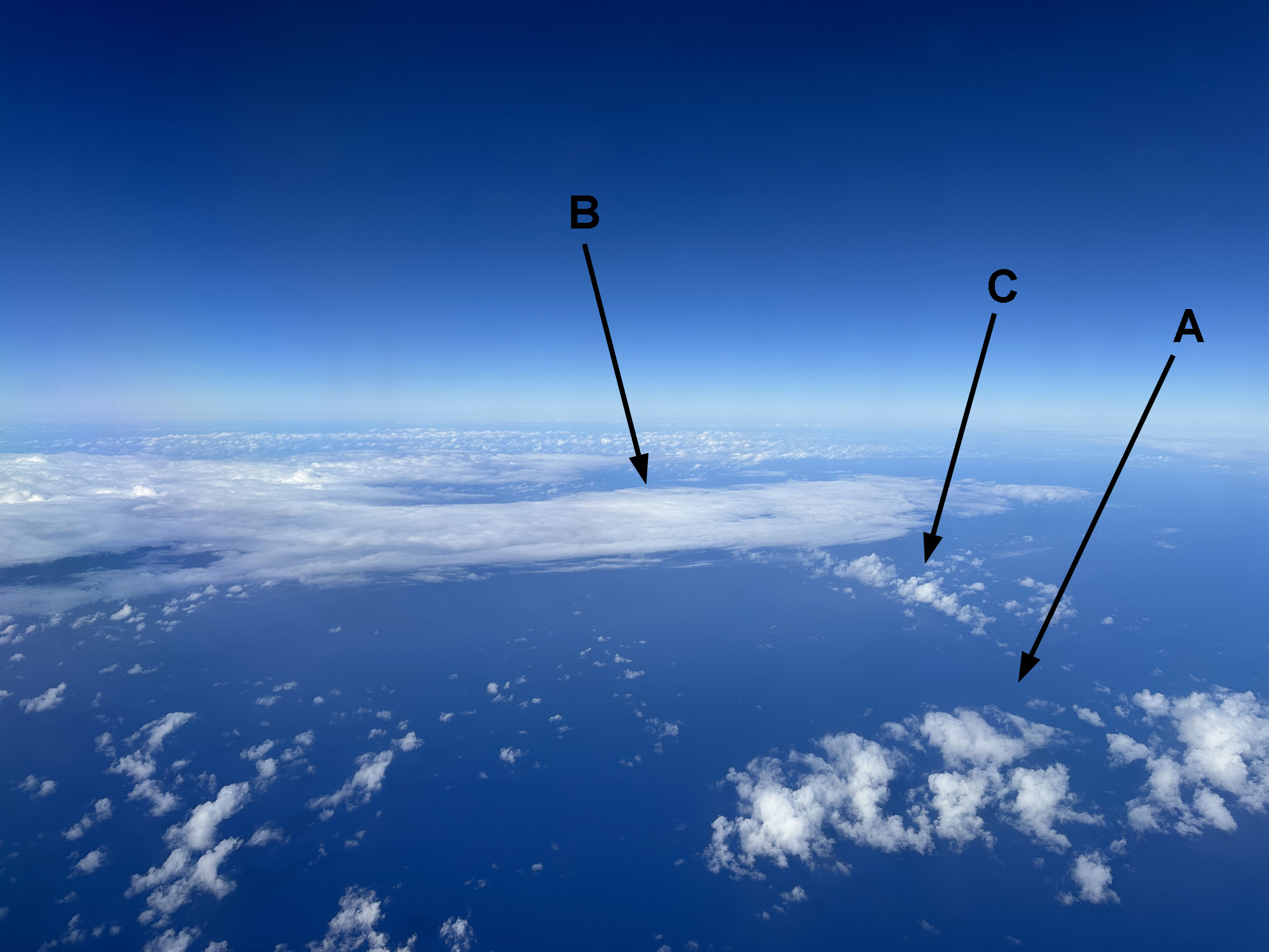
The second image was taken 5 minutes later while the aircraft was over the Alenuihāhā Channel between the Big Island and Maui. I’ll use the same GOES visible image from 3:15 PM HST since it’s the closest in time to the 3:19 PM HST picture. The “A” feature is the base of the “Y” identified in the previous pair of figures. Feature “B” is a thin layer of stratocumulus extending east of Kīpahulu on the southeast flank of Haleakalā, Maui. I don’t have the earlier images but my guess is that this deck of clouds formed a few hours earlier in response to daytime heating of the slopes of Halekala. If you refer back to the image loop, this deck of clouds is actually moving eastward while the clouds at “A” and “C”, with lower bases, are moving toward the west. One thing to keep in mind is that satellite images only show you the tops of the clouds so you don’t know how thick it is. However, a trained and/or experienced meteorologist or analyst can often tell what type of cloud it is, and from there have a rough idea if it’s a stable, layered cloud a few tens or hundreds of feet thick, or if it’s a deeper cumuliform cloud a few hundreds or even thousands of feet thick with possible showers. The line of clouds that make up feature “C” is barely resolvable in the visible satellite image. These clouds, with bases at around 2000 to 3000 feet were moving westward and disappeared from the satellite image taken just 10 minutes later. The clouds could have still been there, but decreased in size so that they were too small to be resolved by the satellite’s imager.

Picture taken at 3:19 PM HST. Features “A”, “B”, and “C” are identified in the 3:15 PM HST satellite image below.

Same satellite image as above, but annotated for features “A”, “B”, and “C” in the 3:19 PM HST picture above. The “X” marks the approximate position of the aircraft.
Another 5 minutes passes and the aircraft is over Kahoʻolawe. A view of Maui to the north shows a significant deck of mostly stratocumulus with some embedded cumulus clouds. A portion of the deck, identified as feature “A” in the images below, is just offshore from Kīhei and Māʻalaea. The northern portion of “A” is also barely visible in the satellite image, probably due to the small size of the individual cloud elements. The portion of the deck over the southwest flank of Haleakalā, feature “B”, is solid with no gaps, and this can also be seen in the satellite image. Feature “C” is the gap in the cloud deck over Kīhei and Māʻalaea. This gap is large enough to be resolved in the satellite image. Farther to the west, numerous cumulus clouds can be seen over the slopes of the West Maui Mountains. Since the trade wind inversion that limits cloud development was at about 6,000 feet on this day, the cumuli are only a few thousand feet tall and don’t have enough depth to produce significant rain. The U.S. Geological Survey’s Puʻu Kukui rain gage did not record any rainfall that afternoon and it’s normally the wettest spot in the West Maui Mountains.

Picture taken at 3:24 PM HST. Features “A”, “B”, “C”, and “D” are identified in the 3:25 PM HST satellite image below.

Visible satellite image from 3:25 PM HST. The “X” marks the approximate position of the aircraft. Annotations on the image are the features identified in the picture above from 3:24 PM.
The final image I wanted to highlight is from 3:37 PM. The aircraft is lower and slower south of Oʻahu as it approaches the air traffic pattern into Honolulu Airport. Feature “A” in the images is the line of cumulus clouds over the slopes of the Koʻolau Range. Like the clouds over West Maui, these clouds don’t have sufficient vertical extent to be producers of much, if any, rainfall. One interesting feature in the aircraft picture is the thin gray line extending east or northeast from the clouds over Oʻahu. I don’t know for sure if this is a cloud layer or haze layer, but in either case it wasn’t detectable by the satellite.

Picture taken at 3:37 PM HST. Feature “A” is identified in the 3:35 PM HST satellite image below.

Visible satellite image from 3:35 PM HST. The “X” marks the approximate position of the aircraft just after the satellite image was taken. Feature “A” on the satellite image is identified in the picture above from 3:37 PM.
Maybe you found this whole exercise less interesting than watching grass grow, but I thought it was interesting to do a detailed comparison between what is shown in the satellite images versus what you can see out of the airplane. If I’m on a flight during a more active weather pattern, I may do this kind of analysis again.