
Note: This blog post will NOT be updated with the latest position and forecast information regarding Lala. I will likely provide short content updates via my Instagram feed. For the latest official tropical cyclone forecasts, watches, and warnings, please go to hurricanes.gov. For the latest information on local weather, water, and marine impacts from Lala, please go to the Honolulu Forecast Office website.
Well, here we are, it’s Friday, August 14, and I’m watching Tropical Storm Lala as it approaches the Big Island. At 11 AM HST this morning, Lala was centered about 340 miles east-southeast of South Point on the Big Island and moving towards the west-northwest at 14 miles per hour. Its maximum sustained winds were 60 miles per hour and it kept a steady intensity overnight. The satellite loop below is zoomed in and centered on Lala. You know trouble is near when the islands show up in the zoomed-in loop for an approaching tropical cyclone!

NOAA/NESDIS GOES-18 “Sandwich RGB” loop combining visible images in gray shades and infrared images in bright colors. The visible images show the low clouds while the color enhanced infrared portions highlight thunderstorms and high clouds. The loop uses images from the morning of August 14, 2026. Please click on the link for more information about the Sandwich RGB.
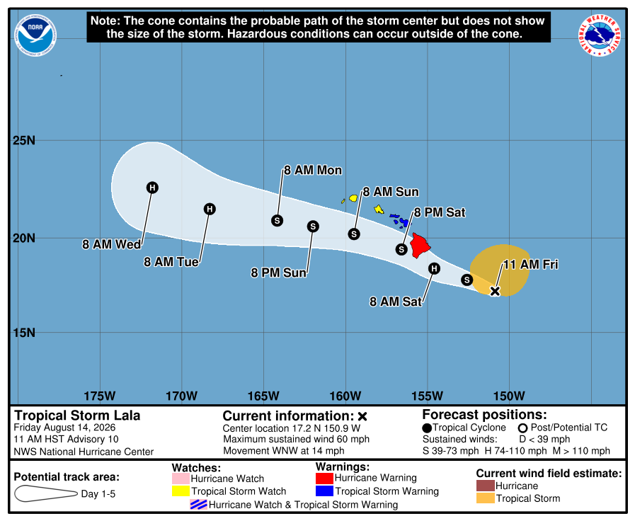
According to the 11 AM HST Friday forecast from the National Hurricane Center (NHC), Lala is expected to continue moving west-northwestward over the next several days, though there may be some temporary deviations in the track as the tropical cyclone interacts with the Big Island. On the forecast track, the center of Lala is expected to pass over or just south of the Big Island on Saturday. Keep in mind that tropical storm force winds will arrive well before then, possibly as early as just before midnight Saturday but most likely a few hours before sunrise Saturday morning. Lala should strengthen more and is forecast to be a Category 1 hurricane by the time it reaches the Big Island.
The National Hurricane Center (NHC) has the Big Island under a Hurricane Warning. This means hurricane conditions are expected somewhere on the Big Island within 36 hours. The timing of the warning is based on the onset time of tropical storm force winds because it’s too dangerous to continue preparations beyond that time. NHC also has all of Maui County under a Tropical Storm Warning. This means that tropical storm conditions are expected over Maui County in the next 36 hours. Oʻahu and Kauaʻi County are under a Tropical Storm Watch, which means tropical storm conditions are possible in the next 36 to 48 hours.

Tropical cyclone forecast cone graphic issued at 11 AM HST Friday, August 14, 2026 by the National Hurricane Center. Dots are forecasted center positions over the next five days. The light blue swath indicates the forecast error cone.

Graphic showing the earliest reasonable arrival time (a.k.a. “reasonable worst case”) and probability of tropical storm force winds issued at 11 AM HST Friday, August 14, 2026 by the National Hurricane Center.
Based on the forecast, Big Island residents will be experiencing the full “triple threat” of tropical cyclone hazards…strong winds, significant flash flooding, and combined high surf and storm surge. The rainfall forecast for Lala (below) shows a large area of 16 to 20 inches over the east side of the Big Island, with isolated amounts of 25+ inches. This amount of rainfall will produce significant flooding over the southeast half of the island. Fortunately, Lala is moving at a decent speed which means it’s not expected to produce rainfall on the level of Hurricane Lane in 2018 (58 inches!). The total rainfall from Lane was so high mainly because of the slow movement of the hurricane which allowed rain bands to move over the Big Island for several days.
Winds, rainfall, and surf/surge on the other islands will be significant, but considerably less than what will be experienced on the Big Island. Highly localized enhancements due to terrain can cause impacts above what may be forecast. One example occurred during the passage of Tropical Storm Iselle in 2014. Strong tropical storm force winds hit the southeast half of the Big Island but were weaker over the northern portion of the island farther from Iselle’s landfall near Pāhala. You would think that Maui’s winds would be even less, but ʻUlupalakua Ranch on the southwest flank of Haleakalā experienced significant damage to structures from very strong winds that possibly included gusts above hurricane strength (based on the level of damage). It was hypothesized that winds forced between Maui and the Big Island and accelerating around the flank of Haleakalā produced the damaging winds at the ranch.

Forecasted total rainfall from Lala, issued by the National Weather Service’s Weather Prediction Center on August 14, 2026.
Some may be asking, why didn’t Lala weaken and die like Fausto last month? Fausto faced much more hostile environmental conditions in the form of marginal sea surface temperatures (SSTs), strong vertical wind shear, and dry mid-tropospheric air. All of these factors combined to severely weaken Fausto as it approached the state. None of these factors are sufficiently present with Lala. The SSTs along Lala’s projected path should be at or above 27 degrees C (see below), more than adequate to sustain or strengthen a tropical cyclone. Vertical shear may increase a bit over the next day or so, but not enough to cause significant weakening. Dry mid-tropospheric air is around the tropical cyclone, but doesn’t appear to be impinging or wrapping into Lala’s circulation enough to cause weakening. So for those thinking, “nah, going be like Fausto and die”, I’m afraid you’ll be disappointed.

Sea surface temperature analysis (degrees C) valid at 2 AM HST Friday, August 14, 2026 from the HAFS-A tropical cyclone model. The graphic is produced by Tropicaltidbits.com. Annotations in black are my own.
With Lala’s arrival over the Big Island only a day away, preparations by island residents should be finalized, especially since there’s only half a day of sunlight left. Follow the instructions from your county emergency managers and please take the threat seriously. Lala is expected to impact the Big Island with winds stronger than Tropical Storm Iselle in 2014, and is forecast to be closer to the Big Island than Hurricane Hone’s passage in 2024. If you recall those tropical cyclones, impacts from Lala should be worse.
As I’ve done in the past, I added a list of links below for planning and preparedness information that you may find useful:
- Hawaiʻi Emergency Management Agency (HIEMA): HIEMA’s website contains a wealth of preparedness information not just for tropical cyclones, but many natural hazards.
- County Emergency Management Agencies: Your respective county emergency management offices will have specific information affecting your county, including availability and status of evacuation shelters.
Finalize your preparations and stay safe!