
Note: This blog post will NOT be updated with the latest position and forecast information regarding Moke. I will likely provide short content updates via my Instagram feed. For the latest official tropical cyclone forecasts, watches, and warnings, please go to hurricanes.gov. For the latest information on local weather, water, and marine impacts from Moke, please go to the Honolulu Forecast Office website.
Wow, this feels like déjà vu. Wow, this feels like déjà vu. A week ago today, I wrote about then Tropical Storm Lālā approaching the Big Island from the east-southeast. At that time, I thought this week I would be doing a follow-up on Lālā with an analysis of the rainfall and winds. But here we are. Another tropical system heading our way. The Lālā analysis will have to wait.
This time, it’s Moke. As of 11 AM HST Friday, August 21, the National Hurricane Center (NHC) upgraded Tropical Depression 2-C to Tropical Storm Moke. The satellite image loop (below) shows that most of Moke’s deep convection is displaced to the north and northeast of the center, and the low level circulation center is mostly exposed. This kind of asymmetry usually indicates that vertical wind shear is affecting the system. A vertical wind shear analysis from the Cooperative Institute for Meteorological Satellite Studies (CIMSS) shows moderate to strong southwesterly shear impacting the cyclone. Despite the vertical shear, an Air Force Reserve WC-130J aircraft from the 53rd Weather Reconnaissance Squadron (a.k.a “Hurricane Hunters”) found flight level winds northeast of the center that supported the presence of tropical storm force winds at the surface.

NOAA/NESDIS GOES-18 “Sandwich RGB” loop centered on Tropical Storm Moke combining visible images in gray shades and infrared images in bright colors. The visible images show the low clouds while the color enhanced infrared portions highlight thunderstorms and high clouds. The loop uses images from the morning of August 21, 2026. Please click on the link for more information about the Sandwich RGB.

Northeast Pacific vertical wind shear analysis from the Cooperative Institute for Meteorological Satellite Studies (CIMSS) at 8 AM HST, August 21, 2026. Red contours show regions of strong vertical wind shear. Salmon-colored vectors show the direction of the shear. Annotations in yellow are my own.

Flight level winds plot from a WC-130J mission into Tropical Storm Moke from the morning of August 21, 2026. The strongest winds along the flight track were to the northeast of the center and supported upgrading Tropical Depression 2-C to Tropical Storm Moke. The graphic is produced by Tropicaltidbits.com. Annotations are my own.
While it’s unfortunate that residents of Hawaiʻi have to deal with another tropical cyclone so soon after Hurricane Lālā, the good news is that this isn’t another Lālā. The 11 AM HST track forecast (cone graphic below) has Moke passing farther south of the state than Lālā did. According to NHC, it’s also a weaker and more compact tropical cyclone so the current forecast does not call for a Tropical Storm Watch or Tropical Storm Warning. Why is Moke not currently forecast to become a hurricane like Lālā? First, vertical shear is already affecting Moke and is expected to persist over the next several days. Another factor is mid-tropospheric dry air, which is expected to affect Tropical Storm Moke more than it did with Lālā. The 500 millibar relative humidity graphic shows dry air impinging on the west side of the cyclone and even wrapping into the southeastern portion of the circulation. These factors should limit Moke’s development and maybe even cause weakening, especially later this weekend and early next week.

Tropical cyclone forecast cone graphic issued at 11 AM HST Friday, August 21, 2026 by the National Hurricane Center. Dots are forecasted center positions over the next five days. The light blue swath indicates the forecast error cone.

Forecast of relative humidity (%) at 500 millibars valid at 6 PM HST Saturday, August 22, 2026 from the 2 AM HST Friday, August 21 run of the ECMWF model. Brown colors indicate dry air. Graphic provided by WeatherBELL Analytics. Annotations in black and yellow are my own.
In terms of impacts, the main concern, according to the Honolulu Forecast Office, is the threat of heavy rainfall and flash flooding. The forecast amounts (below) may not be as high as what occurred during Lālā, but the southeastern portion of the Big Island is very fragile right now so any heavy rainfall over residually saturated soils could produce flash flooding quicker than usual. Many drainage channels from Kapāpala to Waiōhinu are filled with rocks and debris, reducing channel capacity and the ability to carry floodwaters. This increases the risk of alternate flow paths downslope. Temporary roads spanning channels with washed out bridges are also at significant risk from any flooding.
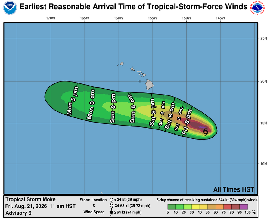
As for the winds, based on the tropical storm force probabilities graphic, the entire state is currently outside of the 5 percent chance swath, so that’s nice to see. However, even if the winds remain below tropical storm force, it will still be rather breezy, especially on Sunday. Keep in mind, though, that the forecast could change if Moke doesn’t behave as expected so stay tuned for the latest information!

Tropical Storm Moke rainfall forecast from the Honolulu Forecast Office briefing on August 21, 2026.

Graphic showing the earliest reasonable arrival time (a.k.a. “reasonable worst case”) and probability of tropical storm force winds issued at 11 AM HST Friday, August 21, 2026 by the National Hurricane Center.
As I typically do for upcoming significant weather events, I added a list of links below for planning and preparedness information that you may find useful:
- Hawaiʻi Emergency Management Agency (HIEMA): HIEMA’s website contains a wealth of preparedness information not just for tropical cyclones, but many natural hazards.
- County Emergency Management Agencies: Your respective county emergency management offices will have specific information affecting your county, including availability and status of evacuation shelters.
While we wait to see what Moke has in store for us, we can at least take the lessons learned from our Lālā experience and make adjustments to our preparations. And even if Moke’s impacts end up being minimal, we still have several months left in the tropical cyclone season so don’t be too hasty about reverting back to a pre-tropical cyclone season posture.