
Back on February 20th, I did a post on what clouds in weather satellite images look like from an airplane. The weather conditions on the day of that flight were fairly benign, with light low level winds from the east to southeast. Despite the stable conditions, there were still interesting features to identify, but I thought it would be really interesting to do a similar thing during unsettled weather. I didn’t have to wait too long for that opportunity. On May 15th, a low pressure system aloft brought unstable atmospheric conditions to portions of the state. The event produced thunderstorms, flash flooding, and even small hail over Oʻahu, which I wrote about in last week’s post.
Fortunately, I was flying back home through all that! While waiting for my delayed flight at the Hilo Airport terminal, I could see there was a lot of weather action going on over Oʻahu. The loop below, which was also in last week’s post, showed numerous lightning flashes, especially over central and west Oʻahu.

NOAA/NESDIS visible image loop centered on the main Hawaiian Islands with Geostationary Lightning Mapper (GLM) data overlaid. The loop covers the period from 1:01 PM to 3:01 PM HST, May 15, 2026. For more information on the GLM data, please click here.
The last time I did this, I was seated on the right side of the plane. This time I was on the left, so my view was mainly to the south and southwest as we headed toward Oʻahu. The first image I wanted to show was taken at 4:44 PM HST. At the time, the plane was at an altitude of about 17,000 ft just northeast of Honokaʻa over the Big Island’s Hāmākua Coast. This position is marked by the “X” in the infrared satellite image below, taken at 4:40 PM HST. The light gray striated band of clouds over the northern portion of the Big Island is a layer of cirrus associated with the low pressure system aloft. The southeastern edge of this band is identified as feature “A” in the satellite image. The picture from the plane shows the edge of the cirrus band (feature “A”) well above our flight level.
You can also see the summit of Mauna Kea (feature “B”), surrounded by the tops of a mixture of cumulus and stratocumulus clouds. This is also identified as feature “B” in the infrared satellite image. Normally, clouds don’t get this high up the slopes of Mauna Kea and Mauna Loa. However, the trade wind inversion, which is usually at 7,000 to 7,500 ft, was at about 11,500 ft on the afternoon of May 15. This allowed clouds to get farther up the slopes of the Big Island (see skew-t diagram below).
An interesting item seen in the infrared image, but not visible from the aircraft, is identified as feature “C”. This small, dark feature in the satellite image is the hot spot from Kīlauea volcano. Fountains from episode 47 of the ongoing eruption ended the previous night, but the summit of Kīlauea was still very hot and showed up nicely.

NOAA/NESDIS GOES-18 color enhanced infrared (IR) image centered over the Big Island at 4:40 PM HST, May 15, 2026. The “X” marks the approximate position of the aircraft at 4:44 PM HST. Features “A” and “B” correspond to features in the picture below taken from the aircraft.

Picture I took out the left side window of the aircraft at 4:44 PM HST, May 15, 2026. Features “A” and “B” in the picture are the same features identified in the 4:40 PM HST satellite image above.

Plot of data from the Hilo Airport balloon sounding at 2 PM HST, May 15, 2026. Vertical bold black lines are temperature (right) and dew point (left). The red arrow points to the level of the trade wind inversion, which was weak at the time of the sounding and more clearly identified by a corresponding significant decrease in moisture. Plot downloaded from the Univ. of Wyoming Atmospheric Science Radiosonde Archive.
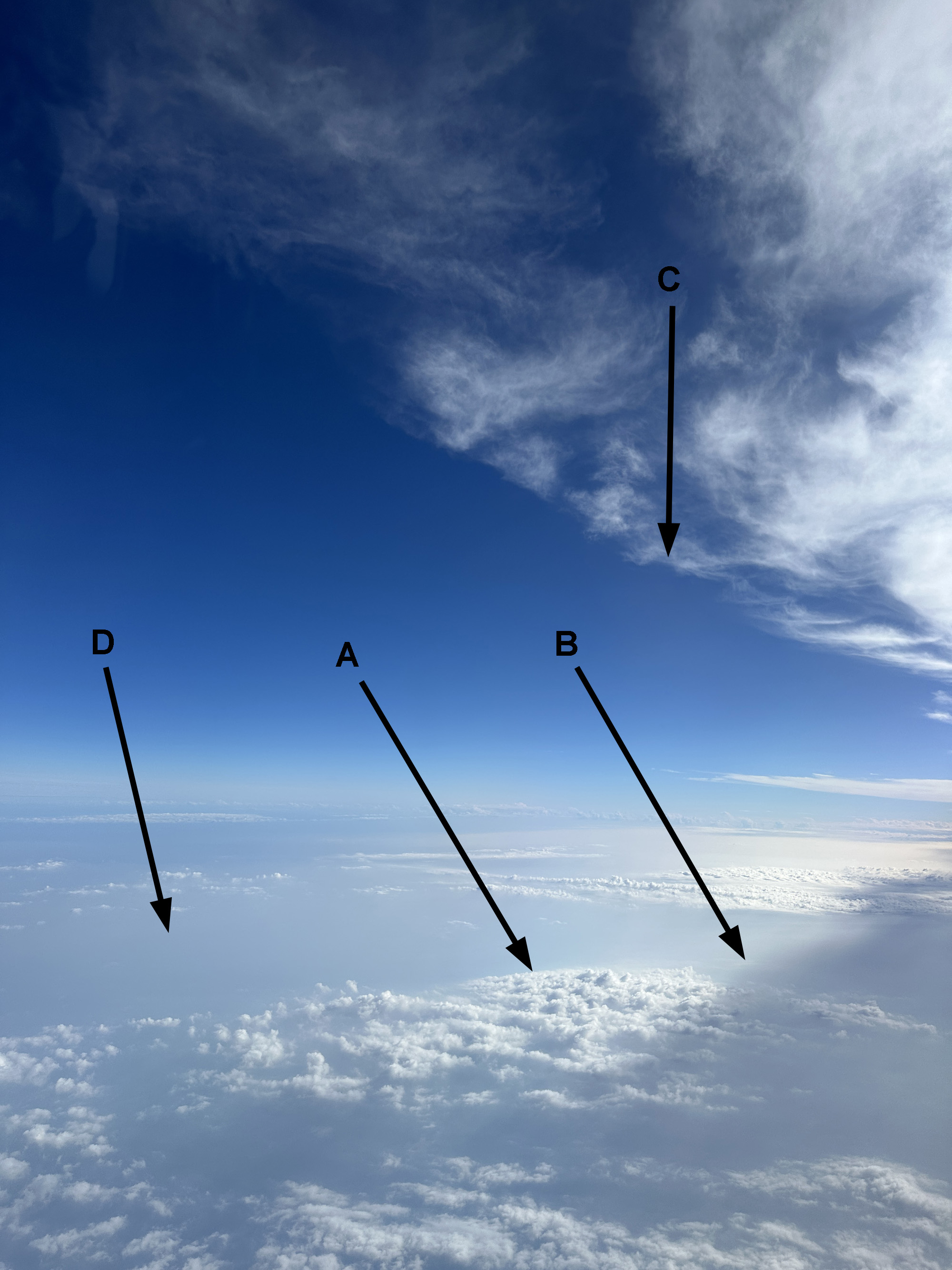
The second image of interest was from 4:52 PM HST. The aircraft was at a cruising altitude of 24,000 ft south of the ʻUlupalakua portion of Maui and heading toward Kahoʻolawe. This is marked by the “X” in the GOES visible satellite image below from 4:50 PM HST. At this point, we were starting to pass under the edge of some thunderstorm anvil cirrus. There’s a lot going on here. First, there’s a patch of low clouds southeast of Kahoʻolawe, marked as feature “A” in both the satellite and aerial images. The edge of the shadow cast by the anvil cirrus (feature “B”) is significant enough to be seen in the satellite image as well. The edge of the cirrus itself is identified as feature “C” in both images.
Looking out the window during this portion of the flight, I noticed that it seemed to be pretty hazy below our flight level. So much so that it was difficult to see the ocean surface. I realized that it must be an elevated layer of vog lofted by the recent eruption. It’s pretty evident in the aerial image. In the visible satellite image, you can see a slightly lighter swath to the south of the anvil cirrus (feature “D”). It was rather faint in the actual satellite image so I adjusted the brightness levels using software. The overall image is more washed out than the actual image but you can see the haze layer better at “D”.
Feature “E” in the satellite image is not visible in the aerial image, but I thought it would be interesting to point out. This is the overshooting top of a developing cumulonimbus south of Oʻahu. At 4:50 PM HST, it looks like a pimple punching through the existing anvil cirrus from earlier thunderstorm activity. One of the nice things about later afternoon (and early morning) visible images is that the lower sun angle produces larger shadows to provide depth to the scene.

Visible satellite image from 4:50 PM HST. The “X” marks the approximate position of the aircraft at 4:52 PM HST. Features “A”, “B”, “C”, and “D” are identified in the aerial picture from 4:52 PM HST below. Feature “E” south of Oʻahu is not visible in the aerial picture.

Picture taken at 4:52 PM HST. Annotations on the image are the features in the satellite image above from 4:50 PM HST.

Same as the above 4:50 PM HST visible satellite image, but with the brightness levels adjusted to better see the haze layer identified as feature “D”.
The third picture I wanted to show was taken at 5:12 PM HST (below). At this point, we were below 3,000 ft beneath an overcast cloud deck heading toward Honolulu Airport. Despite the trade winds earlier in the day, the disrupted low level flow from the thunderstorm activity produced light north winds at the time of arrival of our flight. This allowed us to land on Runway 26-Left (Reef Runway). If we used Runway 08-Left or Runway 04-Right as is usually the case during trade winds, we would have flown through more nasty conditions in the approach pattern, or not even attempted it at all depending on how bad it was.
The aerial picture shows the new thunderstorm that developed south of Oʻahu. It’s really dark from the heavy rain and the thick cloud mass of the cumulonimbus. The visible satellite image below from 5:10 PM HST shows how much the overshooting top (feature “A”) has expanded compared to the “pimple” from 20 minutes prior. A corresponding infrared image shows the overshooting portion as cooler and higher cloud tops in green, compared to the warmer and lower tops in blue. Overlaying Multi-Radar/Multi-Sensor (MRMS) radar reflectivity on the visible satellite image (last image below) shows heavy rain in dark red within the overshooting cloud tops.

Image taken at 5:12 PM HST showing a cumulonimbus cloud with heavy rain southwest of the aircraft.

Visible satellite image from 5:10 PM HST. The “X” marks the approximate position of the aircraft at 5:12 PM HST. Feature “A” marks the position of the thunderstorm in the aerial image.

Same satellite image as above, but from the infrared channel.

Visible satellite image from 5:10 PM HST overlaid with MRMS Seamless Hybrid Scan Reflectivity data from 5:12 PM HST.
While my first aerial vs. satellite image post showed some interesting features in a benign weather pattern, this version had a lot more to show at different levels. While there was a lot of weather activity, the flight itself was surprisingly smooth. The pilot warned us of possible bumpy conditions near Honolulu, but none of that materialized. Maybe next time I can do a post from inside a tropical cyclone, if I can get a ride with the Hurricane Hunters. That would be pretty cool!