
Note: This blog post will NOT be updated with the latest position and forecast information regarding Fausto. I will likely provide short content updates via my Instagram feed. For the latest official tropical cyclone forecasts, watches, and warnings, please go to hurricanes.gov. For the latest information on local weather, water, and marine impacts from Fausto, please go to the Honolulu Forecast Office website.
By now, most of you are probably aware that there’s a hurricane named Fausto out there to the east of the Hawaiian Islands. If you weren’t aware, then I guess the title of the post clued you in to the news. As of 5 AM HST this morning, Fausto had maximum sustained winds of 105 miles per hour, making it a category 2 system on the Saffir-Simpson Hurricane Wind Scale. Fausto became better organized overnight following a burst of convection around the eye at around sunset yesterday. Since then, Fausto’s eye has become more ragged, which may be an indication that hurricane has passed its peak intensity.

NOAA/NESDIS GOES-18 color enhanced infrared (IR) image loop covering the tropical central and east Pacific on the morning of July 24, 2026. In this enhancement curve, yellow/orange/red colors show the coldest (and highest) cloud tops from thunderstorm activity. Lighter gray shades are low clouds, and the darker gray areas are the ocean or land areas.

Zoomed in GOES IR loop centered on Hurricane Fausto produced by Tropicaltidbits.com. The loop covers the period from 8:55 AM – 11:15 AM HST Friday, July 24, 2026.
Fausto is south of a mid-level ridge of high pressure, which means that its steering current is taking it towards the west. The ridge is expected to remain in place for a while so little change is expected in its motion. It also means that Fausto should cross 140W longitude some time in the middle of this weekend and become the Central North Pacific Basin’s first tropical cyclone of 2026.
Early this week, most model track forecasts had Fausto passing well north of the main Hawaiian Islands. As the week went on, the guidance envelope shifted closer to the island chain, and it has remained that way since then. The latest compilation of track forecasts (first map below), from 8 AM HST Friday, showed most of the solutions having the center of Fausto passing over or just north of the state some time late Tuesday or early Wednesday.
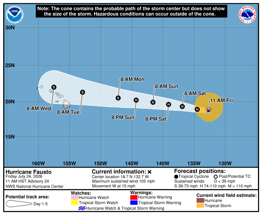
Just because most of the lines are north of the state does not mean it’s game over with nothing to worry about for Hawaiʻi. At five days out, a lot can change! All of the main Hawaiian Islands are easily within the forecast error cone, as shown below in the NHC’s 11 AM HST Friday forecast graphic.

Track forecasts for Hurricane Fausto from various models and objective aids, valid as of 8 AM HST, July 24, 2026. Graphic provided by WeatherBELL Analytics.

Tropical cyclone forecast cone graphic issued at 11 AM HST Friday, July 24, 2026 by the National Hurricane Center. Dots are forecasted center positions over the next five days. The light blue swath indicates the forecast error cone.
The track forecast, with its uncertainties, is one thing. A bigger question right now is what Fausto’s intensity will be once it reaches the island chain. Between now and the middle of next week, Fausto will have to contend with several factors detrimental to its health. One is that it will be traversing marginal sea surface temperatures. This is shown in the forecast panel below from the HAFS-A model valid at 8 AM HST Saturday, July 25. The center of Fausto is over waters just below 26.5C (80F) and should remain over similar water temperatures as it approaches the state. What’s so special about 26.5C? It’s considered to be a threshold needed to sustain a tropical cyclone. Does a tropical cyclone suddenly die if the water is colder than 26.5C? No, but waters cooler than that temperature make it less likely for a tropical cyclone to maintain its strength. Another factor is a large swath of dry mid-tropospheric air. Dry air in these levels can disrupt the convection needed to sustain the cyclone and can lead to weakening. The water vapor loop below shows a significant amount of dry mid-tropospheric air between Fausto and the Hawaiian Islands. The model forecast panel from the ECMWF valid at 8 AM HST Sunday, July 26 shows the dry air impinging against the tropical cyclone and even wrapping around to the southeast of its center. Lastly, vertical wind shear affecting Fausto is expected to increase as it approaches the state due to the presence of the subtropical jet stream northwest of Kauaʻi. Strong vertical shear, usually greater than 25 to 30 knots, can disrupt the core of the tropical cyclone and lead to weakening.
The degree to which these factors impact Fausto will affect its intensity. The various models all forecast weakening over the next several days, but at widely varying rates. The impacts on the islands will depend greatly on Fausto’s intensity when it arrives and it is simply much too early to know with confidence right now what its intensity will be at that time.

Sea surface temperature forecast (degrees C) valid at 8 AM HST Saturday, July 25, 2026 from the 2 AM HST Friday, July 24, 2026 run of the HAFS-A tropical cyclone model. The graphic is produced by Tropicaltidbits.com. Annotations in black are my own.

NOAA/NESDIS GOES-18 color enhanced water vapor image loop covering the central and eastern Pacific on the morning of July 24, 2026. The yellows and oranges between Fausto and the Hawaiian Islands indicate dry middle and upper tropospheric air.

Forecast of relative humidity (%) at 500 millibars valid at 8 AM HST Sunday, July 26, 2026 from the 2 AM HST Friday, July 24 run of the ECMWF model. Brown colors indicate dry air. Graphic provided by WeatherBELL Analytics. Annotations in black and yellow are my own.

Forecast of 850 to 200 millibar wind shear (knots) valid at 2 AM HST Tuesday, July 28, 2026 from the 2 AM HST Friday, July 24 run of the ECMWF model. Graphic provided by WeatherBELL Analytics. Annotations in black are mine.
In terms of impacts to the state, a big thing to keep in mind is that the forecast positions are just for the center of Fausto. Strong winds, heavy rain, and high surf can extend well away from the tropical cyclone’s center so avoid focusing just on the locations on the track lines and position dots. Since it’s too early to know the specifics on these impacts, the important thing to do right now is prepare and stay informed. The following graphic includes guidance through the weekend from the Honolulu Forecast Office. The “NOAA G-IV” refers to the Gulfstream IV aircraft used by NOAA to sample the large scale environment surrounding Fausto. Data from the G-IV missions are fed into the forecast models to improve the guidance on the tropical cyclone. The Air Force Reserve WC-130Js are also known as the “Hurricane Hunters” of the 53rd Weather Reconnaissance Squadron. They will be flying into Fausto to collect data on the center location, intensity, and structure of the cyclone, and provide details on its surrounding wind field. The data they collect will also help improve the model guidance for the forecasters.

If you’re looking for planning and preparedness information, here are some links you may find useful:
- Hawaiʻi Emergency Management Agency (HIEMA): HIEMA’s website contains a wealth of preparedness information not just for tropical cyclones, but many natural hazards.
- County Emergency Management Agencies: Your respective county emergency management offices will have specific information affecting your county, including availability and status of evacuation shelters.
Have a plan, be prepared, and stay safe!